The Quaternary period spans roughly the last 2 million years and is subdivided into two epochs. These are the Pleistocene which ended approximately 10,000 years ago and the Holocene, representing our modern day climatic conditions. It is the climatically controlled processes associated with the Pleistocene which have had a profound influence upon landform development within the Malvern Hills and the surrounding lowland areas. The Pleistocene climate fluctuated between warm temperate (interglacial) and cold (glacial) climatic conditions, comparable to present day arctic environments (Table One). Climatic reconstructions based upon comparisons with modern day environments suggest that the mean annual air temperature in Britain during the Late Devensian were between -6 and -12°C. Winter temperatures probably reached as low as -15 to -20°C.
| Stage | Approximate Date | Events and Climatic conditions | Deposits |
| Flandrian | Temperate | Post-Glacial sea level rise | |
| Pleistocene-Holocene Boundary | |||
| Late Devensian | 10000 – 26000 | Glacial. Diversion of the River Severn. | Head |
| Middle Devensian Stage
Early Devensian Stage | 122 000 | Glacial/ interglacial.Glacial | Head |
| Ipswichian | 132 000 | Interglacial, temperate | |
| Wolstonian | 352 000 BP | Cold temperate climate | Colwall Member |
| Hoxnian
Anglian Stage | 428 000 BP
480 000 BP | Interglacial, temperateGlacialInterglacial, temperate | Cradley Beds
Coddington Brays |
Table One: Summary of the Quaternary deposits of the Malvern Hills and Surrounding Area.
Quaternary Deposits around the Malvern Hills
The Quaternary deposits around the Malvern Hills range in age from the Anglian to the Flandrian, although it is likely that the interglacial, organic silts of the Brays Bed are pre-Anglian in age. The early Anglian is represented by the coarse sands and gravels of the Mathon Member. These were deposited by a north-south flowing braided river system called the River Mathon, which was located on the western side of the Malvern Axis during Anglian times. Direct evidence of glacial activity within the Malvern Hills is sparse. However, the Coddington Member (formerly the Coddington Till) represents a till deposited at the base of an ice sheet, indicating that the lowland areas surrounding the hills would have been under glacial conditions during the Anglian Stage.
Where did the ice reach?
There has been some debate regarding the direction of ice flow during Anglian times, it has been suggested that ice advanced along the Severn Valley, terminating somewhere near Tewkesbury, in Gloucestershire. The Malvern Hills acted has a barrier to the advancing ice and would have formed nunataks, or small mountains protruding above the surrounding ice sheet. The ice may have reached the western side of the Hills via the fault controlled valleys formed during the Variscan earth movements or by rounding the southern end of the Hills via the Glynch Brook Valley. The westerly diverted ice would have blocked the Glynch Brook Valley, preventing the drainage of the River Mathon. The presence of the silts and clays of the Whitehouse Member would suggest that the Anglian ice sheets blocked the flow of the River Mathon forming an ice dammed glacial lake, which extended northwards towards the Teme Valley, north of Knightwick. However, it has also been suggested that Lake Mathon was formed by the damming of the River Mathon by an ice sheet that advanced across Herefordshire from Wales.
The Anglian ice retreat
Towards the end of the Anglian the climate became warmer and the ice sheets gradually began to retreat. Glacial thinning allowed the sudden drainage of Lake Mathon via rapid torrents of sediment laden water. Large scale flooding occurred along the Glynch Brook valley which acted as a spillway, depositing the Upleadon Gravels. A combination of rapid drainage and a change to warmer, temperate climatic conditions during the Hoxnian saw to the demise of Lake Mathon. The lake was reduced to a stagnant, slow moving body of water, these stagnant conditions resulted in the deposition of the Cradley Beds. During these times the upper reaches of the River Seven drained northwards into the Irish Sea. However glacial re-advance during the Late Devensian blocked its northward flow, diverting it to the present day course through the Ironbridge Gorge.
Devensian Ice age
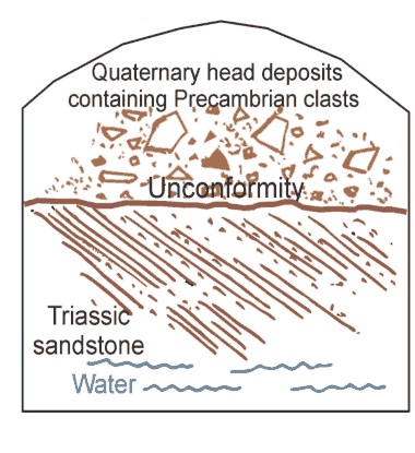
No ice reached the Malvern Hills or the surrounding area during the Devensian since the ice margin halted some 11 km to the west and 55 km to the north of the Hills. However, the area was exposed to extremely cold, periglacial conditions which have been compared to the modern day high latitude zones of Alaska and Northern Scandinavia. Freeze-thaw activity and the frost weathering processes associated with periglacial environments have produced a mantle of superficial debris, covering a large proportion of the lower slopes of the Hills. The debris was derived from the frost shattered Precambrian rocks whose surface layers have been considerably weakened by freeze-thaw activity. Large quantities of this material have been transported downslope and the slopes of the Hills are obscured by a veneer of superficial material. The majority of the Quaternary sediments can only be exposed by digging or augering, however it is possible to examine these superficial deposits in the Bottling Works Spring (SO 77484598) (Figure Fourteen).